Hours after weakening to a tropical storm while crossing Florida peninsula, Ian regains hurricane strength after emerging over the Atlantic Ocean.

Ian has regained hurricane strength as it spun toward South Carolina a day after devastating a cross-section of Florida.
A hurricane warning was issued on Thursday for the South Carolina coast, where the storm was expected to again make landfall on Friday.
The US National Hurricane Center said the storm’s maximum sustained winds increased Thursday to 120kph. It was centred about 390 kilometres south of Charleston, South Carolina, and moving northeast.
Ian made landfall on Wednesday on Florida’s west coast as a powerful Category 4 hurricane with 241 kph winds. The storm flooded homes, cut off a popular barrier island and left nearly 2.7 million people without power before moving over the Atlantic and turning north.
Rescue crews piloted boats and waded through flooded streets on Thursday to save thousands of Floridians trapped after Hurricane Ian destroyed homes and businesses and left millions in the dark.
READ MORE:
Hurricane Ian slams Florida as Category 4 fury
Florida’s devastation
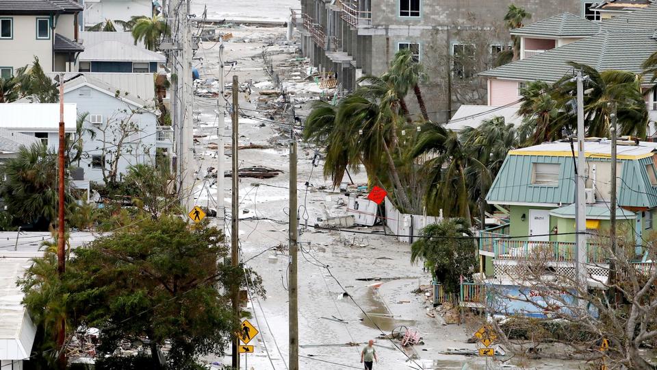
The storm flooded homes on both the state’s coasts, cut off the only bridge to a barrier island, destroyed a historic waterfront pier and knocked out electricity to 2.67 million Florida homes and businesses — nearly a quarter of utility customers. At least one man was confirmed dead.
Aerial photos from the Fort Myers area, a few kilometres west of where Ian struck land, showed homes ripped from their slabs and deposited among shredded wreckage. Businesses near the beach were completely razed, leaving just twisted debris.
“We’ve never seen a storm surge of this magnitude,” Florida Governor Ron DeSantis told a news conference. “The amount of water that’s been rising, and will likely continue to rise today even as the storm is passing, is basically a 500-year flooding event.”
Though downgraded to a tropical storm by Thursday morning, the National Hurricane Center said storm surge and flooding rains remained a threat as Ian crept across the Florida peninsula and emerged in the Atlantic Ocean north of Cape Canaveral.
Forecasters predicted Ian would regain strength while turning northward.
Sheriffs in southwest Florida said 911 centres were inundated by thousands of stranded callers, some with life-threatening emergencies.
The US Coast Guard began rescue efforts hours before daybreak on barrier islands near where Ian struck, DeSantis said. More than 800 members of federal urban search-and-rescue teams were also in the area.
Authorities confirmed at least one Florida death — a 72-year-old man in Deltona who fell into a canal while using a hose to drain his pool in the heavy rain, the Volusia County Sheriff’s Office said. Two other storm deaths were reported in Cuba.
READ MORE: Millions urged to evacuate as Hurricane Ian draws near Florida
‘We’ll see more storms like Ian’
Ian struck Florida as a monstrous Category 4 storm, with 241 kph winds that tied it for the fifth-strongest hurricane ever to hit the US.
While scientists generally avoid blaming the climate crisis for specific storms without detailed analysis, Ian’s watery destruction fits what scientists have predicted for a warmer world: stronger and wetter hurricanes, though not necessarily more of them.
“This business about very, very heavy rain is something we’ve expected to see because of climate change,” said MIT atmospheric scientist Kerry Emanuel. “We’ll see more storms like Ian.”
READ MORE:
Strengthening Hurricane Ian lashes Cuba en route to Florida
Source: AP
Ian regains hurricane strength as it nears South Carolina
Source: News Achor Trending
0 Comments